Ad

Tuesday, July 31, 2012

Ahmedabad

Ahmedabad, also known as Amdavad,is the largest city and former capital of the Indian state of Gujarat. The city is an administrative centre of Ahmedabad district, and is the judicial capital of Gujarat as the Gujarat High Court is in Ahmedabad. Ahmedabad was founded on 26 February 1411 by Sultan Ahmed Shah to serve as the capital of the Gujarat Sultanate, and was named after him. With a city population of more than 5.5 million and an extended population of 6.3 million it is the fifth largest city and seventh largest metropolitan area of India. Ahmedabad is located on the banks of the River Sabarmati, 32 km (20 mi) from the state capital Gandhinagar.

Transport:
  
Air
The airport is located 8 km (5.0 mi) from the Ahmedabad Railway Station. It is named after statesman and former Deputy Prime Minister Sardar Vallabhbhai Patel. The airport is spread over an area of 928.59 acres (3.7579 km2) with the runway measuring 11,500 ft (3,505 m). 


Sardar Vallabhbhai Patel International Airport
The Sardar Vallabhbhai Patel International Airport is located 15 km (9.3 mi) from the city centre. It serves both domestic and international flights to and from Ahmedabad and the neighbouring cities of Surendranagar, Mehsana, and Nadiad. The airport connects the city with destinations across India. 

Rail
Ahmedabad is one of the six operating divisions of the Western Railway. Railway lines connect the city to all towns in Gujarat and other major Indian cities. 


The Ahmedabad Railway Station, locally known as Kalupur Station is the city's main terminus; Ahmedabad's other stations are Maninagar, Vatva, Gandhigram, Asarva, Chandlodia, Kali gam, Vastrapur, Sabarmati, Sarkhej, Naroda and Aamli

Bus Transit

Ahmedabad has a Bus Rapid Transit System (BRTS), maintained by the Ahmedabad Janmarg Limited (AJL). Ahmedabad BRTS was given the Sustainable Transport Award in 2010 by the Institute for Transportation and Development Policy for reducing carbon emissions and improving residents' access.

(BRTS)
 The first phase connecting RTO to Pirana was inaugurated by Chief Minister Narendra Modi on 14 October 2009 and the second half of the first phase connecting Chandranagar to Pushpa Kunj gate at Kankaria was inaugurated on 25 December 2009.


Hyderabad, India

Hyderabad  is the capital of the Indian state of Andhra Pradesh. It is located on the banks of the Musi River in the Deccan Plateau in southern India. The city has an area of 650 square kilometres (250 sq mi) with a population of 6.8 million, and the metropolitan area contains 7.7 million residents, making it the fourth most populous city and the sixth most populous urban agglomeration in the country. As of 2011, the city had per capita annual income of Indian rupee (INR) 44,300. The city was expanded in 2007 to form the Greater Hyderabad Municipal Corporation. As a growing metropolitan city in a developing country, Hyderabad confronts substantial urban pollution, traffic congestion, overpopulation and other logistic and socio-economic problems.

In Hyderabad, public transport such as buses, auto rickshaws and multi modal railways are the most frequently used transport by the residents.

auto-rickshaws
 The composition of vehicles in Hyderabad are—75% two-wheelers, 14% cars, 1% taxis, 4% goods vehicles, 2% buses (including 3,800 RTC buses) and 4% other vehicles (including 71,000 auto rickshaws)

The bus service, governed by Andhra Pradesh State Road Transport Corporation (APSRTC), is the most frequently used means of public transport within the city.

The GARUDA APSRTC Bus
According to the Guinness World Records (2005), APSRTC operates the world's largest fleet of buses, estimated to carry 13 million passengers a day. Mahatma Gandhi Bus Station, located at center of the city, is the main bus station. Parallel to APSRTC under the sponsorship of the Setwin, minibuses are available.

The Secunderabad Railway Station is the headquarters of the South Central Railway zone of the Indian Railways and the largest railway station in Hyderabad.

Secunderabad Railway Station
Other major railway stations are Hyderabad Deccan Station, Kachiguda Railway Station and Begumpet Railway Station.Hyderabad's light rail transportation system, known as the MultiModal Transport System (MMTS), is used by over 150,000 passengers daily, as of 2010.

The Rajiv Gandhi International Airport  was inaugurated in 2008, replacing the previous Begumpet Airport. As of 2010, the Airports Council International (ACI), an autonomous body representing world airports,

Rajiv Gandhi International Airport
had judged RGIA as the world's best airport in the category of serving 5–15 million passengers, and world's fifth best airport for Airport service quality.

Monday, July 30, 2012

Bangalore

Bangalore also rendered Bengaluru  is the capital of the Indian state of Karnataka. Located on the Deccan Plateau in the south-eastern part of Karnataka, Bangalore is India's fifth most populous city and fifth-most populous urban agglomeration.


Bangalore is well known as a hub for India's information technology sector. It is among the top 10 preferred entrepreneurial locations in the world.

Air

Bengaluru is served by the Bengaluru International Airport  which started operations from 24 May 2008. The city was earlier served by the HAL Airport which was India's fourth busiest airport. Kingfisher Airlines has its registered office in Bangalore. It is now the fourth busiest airport in India in terms of passenger traffic and the number of air traffic movements (ATMs) with about 280 per day.

Bengaluru International Airport
The airport is around 40 km from the city centre. The most hassle-free way to commute is by taxi. Meru cabs and Easy cabs have taxis present in the rank at the airport. There are also certain private cab companies.

Rail

A rapid transit system called the Namma Metro is being built. A 7 km stretch from Bayappanahalli to MG Road was opened to public on 20 October 2011.
Namma Metro

Once completed, this will encompass a 42.3 km (26.3 mi) elevated and underground rail network comprising 41 stations.It is expected to connect central locations in Bangalore to Devanahalli and the Chikballapur regions.

This much-delayed project is the city’s primary response to the worsening intra-city transport infrastructure which has become a major deterrent to continued business growth.

Bangalore Metropolitan Transport Corporation (BMTC):
Buses operated by Bangalore Metropolitan Transport Corporation (BMTC) are an important means of public transport available in the city, and are highly reliable. While commuters can buy tickets on boarding these buses, BMTC also provides an option of a bus pass to frequent users.

Bangalore Metropolitan Transport Corporation (BMTC)
BMTC runs air-conditioned luxury buses on major routes, and also operates shuttle services from various parts of the city to the Bengaluru International Airport.

Sunday, July 29, 2012

Delhi

Delhi, officially the National Capital Territory of Delhi (NCT), is the capital of India as well as the country's largest and 2nd most populous metropolis. With 16.7 million residents as of the 2011 census, Delhi is also the 8th most populous metropolis in the world. The region has been given special status of National Capital Region (NCR) under the Indian constitution's 69th amendment act of 1991. There are nearly 22.2 million residents in the greater NCR urban area, which includes the neighboring cities of Ghaziabad, Noida, Greater Noida,Baghpat, Gurgaon, Sonepat and Faridabad along with other smaller nearby towns.

Air:

Indira Gandhi International Airport is situated in the western corner of Delhi and serves as the main gateway for the city's domestic and international civilian air traffic. In 2006–07, the airport recorded a traffic of more than 23 million passengers, making it one of the busiest airports in South Asia. A new INR  96.8 billion (US$1.75 billion) Terminal 3 handles an additional 34 million passengers annually in 2010.

Indira Gandhi International Airport


The Delhi Flying Club was established here in 1928 with two de Havilland Moth aircraft named Delhi and Roshanara was established at Safdarjung Airport which started operations as an airport in 1929, when it was the India's second airport and Delhi’s only airport. The airport functioned until 2001, however in January 2002, due to security considerations in the post scenario, the government closed the airport for flying activities, the club only carries out aircraft maintenance courses today . Today it is mostly used for VVIP helicopter rides to the Indira Gandhi International Airport including the President and the PM.

Rail

The Delhi Metro, a mass rapid transit system built and operated by Delhi Metro Rail Corporation (DMRC), serves many parts of Delhi as well as the satellite city of Gurgaon in the neighbouring Haryana, Noida, and Ghaziabad in neighbouring Uttar Pradesh. As of August 2011, the metro consists of six operational lines with a total length of 189 km (117 mi) and 146 stations while several other lines are under construction. The Phase-I was built at a cost of US$2.3 billion and the Phase-II will cost an additional INR  216 billion (US$3.91 billion). Phase-II of the network is under construction and will have a total length of 128 km and it was completed by 2010.

The Delhi Metro


Delhi is a major junction in the rail map of India and is the headquarters of the Northern Railway. The five main railway stations are New Delhi railway station, Old Delhi, Nizamuddin Railway Station, Anand Vihar Railway Terminal and Sarai Rohilla. In addition to the Delhi Metro, a suburban railway, the Delhi Suburban Railway exists.

Roads

As of 2007, private vehicles account for 30% of the total demand for transport. At 1922.32 km of road length per 100 km2, Delhi has one of the highest road densities in India. Delhi is well connected to other parts of India by five National Highways: NH 1, 2, 8, 10 and 24. Roads in Delhi are maintained by MCD (Municipal Corporation of Delhi), NDMC, Delhi Cantonment Board, Public Works Department (PWD) and Delhi Development Authority.

BusesDelhiDTC
Delhi's high population growth rate, coupled with high economic growth rate has resulted in an ever increasing demand for transport creating excessive pressure on the city's existent transport infrastructure. As of 2008. Also, the number of vehicles in the metropolitan region, i.e., Delhi NCR is 112 lakhs (11.2 million). In 2008, there were 85 cars in Delhi for every 1,000 of its residents. In order to meet the transport demand in Delhi, the State and Union government started the construction of a mass rapid transit system, including the Delhi Metro. In 1998, the Supreme Court of India ordered all public transport vehicles of Delhi to use compressed natural gas (CNG) as fuel instead of diesel and other hydro-carbons.


Mumbai

Mumbai, is the capital city of the Indian state of Maharashtra. It is the most populous city in India, and the fourth most populous city in the world, with a total metropolitan area population of approximately 20.5 million. Along with the neighbouring urban areas, including the cities of Navi Mumbai and Thane, it is one of the most populous urban regions in the world. Mumbai lies on the west coast of India and has a deep natural harbour. In 2009, Mumbai was named an Alpha world city. It is also the richest city in India, and has the highest GDP of any city in South, West or Central Asia.


The seven islands that came to constitute Mumbai were home to communities of fishing colonies. For centuries, the islands were under the control of successive indigenous empires before being ceded to the Portuguese and subsequently to the British East India Company. During the mid-18th century, Mumbai was reshaped by the Hornby Vellard project, which undertook the reclamation of the area between the seven constituent islands from the sea. Completed by 1845, the project along with construction of major roads and railways transformed Bombay into a major seaport on the Arabian Sea. Economic and educational development characterised the city during the 19th century.

Public transport

Brihanmumbai Electric Supply and Transport (BEST) buses:
Mumbai's bus services carried over 5.5 million passengers per day in 2008. Public buses run by BEST cover almost all parts of the metropolis, as well as parts of Navi Mumbai, Mira-Bhayandar and Thane. The BEST operates a total of 4,608 buses with CCTV Camera installed, ferrying 4.5 million passengers daily over 390 routes. Its fleet consists of single-decker, double-decker, vestibule, low-floor, disabled-friendly, air-conditioned and Euro III compliant diesel and Compressed Natural Gas powered buses.

Mumbai's bus
Maharashtra State Road Transport Corporation (MSRTC) buses provide intercity transport and connect Mumbai with other major cities of Maharashtra and India. Navi Mumbai Municipal Transport (NMMT) also operates its Volvo buses in Mumbai, from Navi Mumbai to Bandra, Dindoshi and Borivali.

Suburban rail: 
The backbone of the city's transport, also known as the lifeline of the city, the Mumbai Suburban Railway, popularly known as Locals, consists of three separate rail networks: Central, Western, and Harbour Line, running the length of the city, in the north-south direction.
Suburban rail


Mumbai's suburban rail systems carried a total of 6.3 million passengers every day in 2007, which is more than half of the Indian Railways daily carrying capacity. Trains are overcrowded during peak hours, with nine-car trains of rated capacity 1,700 passengers, actually carrying around 4,500 passengers at peak hours. The Mumbai rail network is spread at an expanse of 319 route kilometres. 191 rakes (ratin-sets) of 9 car and 12 car composition are utilised to run a total of 2,226 train services in the city.

Air:
The Chhatrapati Shivaji International Airport (formerly Sahar International Airport) is the main aviation hub in the city and the busiest airport in India in terms of passenger traffic. CSIA handled traffic of 29.1 million passengers and around 670,2 35 tonnes of cargo in the FY 2010–2011. 

Chhatrapati Shivaji International Airport

An upgrade plan was initiated in 2006, targeted at increasing the capacity of the airport to handle up to 40 million passengers annually.

Taxis:
The Taxis arrived in 1911 to complement horse wagons. The black and yellow Fiat taxis in Mumbai, are integral part of the city's heritage and have been depicted in numerous Bollywood movies. These metered taxis ply throughout Mumbai and have monopoly from Bandra to Churchgate on the Western line and Sion to Chatrapati Shivaji Terminus on the Central line.

An iconic Premier Padmini taxi in Mumbai
 Beyond Sion and Bandra auto rickshaws are not allowed and one has to hire a taxi. However, between Sion to Thane and Bandra to Bhayandar, Taxis and autorickshaws ply. A mechanical meter decides the fare and is proportional to the distance traveled.


Saturday, July 28, 2012

2nd October (Gandhi Jayanti; Mahatma Gandhi’s Birthday)


15th August (Independence Day)


26th January (Republic Day)

National River

National River: Ganga is the national river of India. It is one of the major river in Indian sub-continent. The Ganges is mentioned in the Rig-Veda, the earliest of the Hindu scriptures. Some of the most important Hindu festivals and religious worship happens on the banks of the Ganga river.

National Tree

National Tree: Banyan Tree is the National Tree of India. This huge tree towers over its neighbours and has the widest reaching roots of all known trees. It is the focal point of village life.

National Flower

National Flower: Lotus botanically known as the Nelumbo Nucifera is the national flower of India. It is a sacred flower and occupies a unique position in the art and mythology of the ancient India and has been auspicious symbol of Indian culture since time immemorial.

National Fruit

National Fruit: Mango is the national fruit of India. Described as the "Food of the Gods", in the sacred Vedas, the fruit is grown almost in all parts of India.

National Sport

National Sport: Hockey is the national game of India. It is played all across India. Indian Hockey Federation(IHF) was formed on the 7th November, 1925 at Gwalior. In Olympics, India has won the hockey title a maximum of 8 times.

National Bird

National Bird: The Peacock, Pavo cristatus, is the national bird of India. Emblematic of qualities such as beauty grace, pride. It is a colourful, swan-sized bird, with a fan-shaped crest of feathers, a white patch under the eye and a long, slender neck.

National Animal

National Animal: Tiger is the National Animal of India. It is symbol of India's wildlife wealth. The magnificent tiger, Panthera tigris, is a striped animal. The combination of grace, strength and agility and enormous power has earned the tiger its pride of place as the national animal of India.

National Song

National Song: Bankim Chandra Chatterji's composed song "Vande Mataram" was adopted as the National Song. It has an equal status with "Jana Gana Mana". It was first sung in the 1896 session of the Indian National Congress.

National Anthem

National Anthem : The Jana Gana Mana is the national Anthem of India, composed by Rabindranath Tagore. It was officially adopted by the constituent Assembly as the Indian national anthem on January 24, 1950. It was first sung on December 27, 1911 at the Calcutta (now Kolkata) session of the Indian National Congress. Playing time of the full version of national anthem is approximately 52 seconds. A short version consisting of the first and the last lines of the stanza (playing time approximately 20 seconds) is also played on certain occasions. The whole song consists of five stanzas.

National Emblem

National Emblem : The National Emblem of India is derived from the time of the Emperor Ashoka. The emblem is a replica of the Lion of Sarnath, near Varanasi in Uttar Pradesh. The Lion Capital was erected in the third century BC by Emperor Ashoka to mark the spot where Buddha first proclaimed his gospel of peace and emancipation to the four quarters of the universe.
There are four lions standing back to back, mounted, on an abacus with the frieze carrying sculptures in high relief of an elephant, a galloping horse, a bull and a lion separated by intervening wheels over a bell-shaped lotus. The wheel appears in relief in the centre of the abacus with a bull on right and a horse on the left and the outlines of the other wheel on extreme right and left. The bell-shaped lotus has been omitted. The words Satyameva Jayate from Mundaka Upanishad meaning. Truth Alone Triumphs inscribed below in Devanagari Script.

National Flag

National Flag : The National Flag is the horizontal tricolor of deep saffron (kesaria) at the top, white in the middle, and dark green at the bottom in equal proportion. At the center of the white band is a navy blue wheel, which is a representation of the Ashoka Chakra at Sarnath. Ratio of the width of the flag to its length is 2:3.
Design of the national flag was adopted by the Constituent Assembly of India on July 22, 1947. Its design is that


Biggest, Highest and Largest in India

Highest Award Bharat Ratna
Highest Gallantry Award Param Vir Chakra
Longest River in India The Ganges
Longest Tributary river of India Yamuna
Largest Lake Wular Lake, Kashmir
Largest Lake (Saline Water) Chilka Lake, Orrisa
Largest Man-Made Lake Govind Vallabh Pant Sagar (Rihand Dam)
Largest Fresh Water Lake Kolleru Lake (Andhra Pradesh)
Highest Lake Devtal Lake, Gadhwal (Uttarakhand)
Highest Lake Devatal (Gharhwal)
Highest Peak Karkoram-2 of K-2(8,611 meters)
Highest Peak in the world is Mount Everest which is in Nepal
Largest Populated City Mumbai
Largest State Rajasthan
Highest rainfall Cherrapunhi (426 inches per annum)
Highest Watefall Gersoppar Waterfall (292 meters high) in Mysore
State wise largest area under forest Madhya Pradesh
Largest Delta Sunderbans Delta
Largest River without Delta Narmada and Tapti
Longest Cantilever Span bridge Howrah Bridge
Longest River Bridge Mahatma Gandhi Setu, Patna
Biggest Cave temple Ellora
Longest Road Grand Trunk Road
Highest Road Road at Khardungla,(in Leh-Manali Sector)
Biggest Mosque Jama Masjid at Delhi
Highest Gateway Buland Darwaza at Fatehpur Sikri (53.6 meters high)
Tallest Statue Statue of Gomateshwar (17 meters high In Karnataka
Largest Public Sector Bank State Bank of India
Longest Canal Indira Gandhi Canal or Rajasthan Canal (Rajasthan)
Largest Dome Gol Gumbaz at Bijapur
Largest Zoo Zoological Garden at Alipur (Kolkata)
Largest Museum India Museum at Kolkata
Longest Dam Hirakud Dam (Orrisa)
Highest Dam Bhakra Dam ( 225.5 meters high)
Highest Tower Kutab Minar at Delhi (88.4 meters high)
Largest Desert Thar (Rajasthan)
Largest District Ladakh
Fastest Train Shatabadi Express running between New Delhi and Bhopal
State with longest coastline Gujarat
State with longest coastline of South India Andhra Pradesh
Longest Electric Railway Line From Delhi to Kolkata via Patna
Longest Railway Route From Jammu to Kanyakumari
Longest Railway Platform Kharagpur (W. Bengal)
Longest Platform Kharagpur (West Bengal) 833 meters in Length. It is also the longest railway station in world
Longest Tunnel Jawahar tunnel (Jammu & Kashmir)
Longest Highway NH-7 which turns from Varanasi to Kanyakumari
Smallest State (Population) Sikkim
Smallest State (Area) Goa
Largest State (Area) Rajasthan
Largest State (Population) Uttar Pradesh
Densest Populated State West Bengal
Largest Cave Amarnath (J&K)
Largest Cave Temple Kailash Temple, Ellora (Maharastra)
Largest Animal Fair Sonepur (Bihar)
Largest Auditorium Sri Shanmukhanand Hall (Mumbai)
Biggest Hotel Oberai-Sheraton (Mumbai)
Largest Port Mumbai
Largest Gurudwara Golden Temple, Amritsar
Deepest River Valley Bhagirathi & Alaknanda
Largest Church Saint Cathedral (Goa)
Oldest Church St. Thomas Church at Palayar, Trichur (Kerala)
Longest River Ganga (2640 km long)
Longest Beach Marina Beach, Chennai
Highest Battle Field Siachin Glacier
Highest Airport Leh (Laddakh)
Biggest Stadium Yuva Bharti (Salt Lake) Stadium, Kolkata
Largest River Island Majuli (Brahmaputra River, Asom)
Largest Planetarium Birla Planetarium (Kolkata)

Sports in India

The history of sports in India is very ancient and dates back to the Vedic era. It is more likely that many of today's Olympic disciplines are advanced versions of games of strength and speed that flourished in ancient India. Chess, wrestling, polo, archery and hockey (possibly a fall-out from polo) are some of the games believed to have originated in India.

Following are the some of games played in India
  1. Gilli-Danda: It is a sport played using one small stick called 'gilli' and one long stick called 'danda' like cricket with ball being replaced by Gilli. This games is generally played in villages of Rajasthan, Uttar Pradesh, Madhya Pradesh and Haryana etc states of India.
  2. Kancha: It is played using marbles called 'kancha' in India in cities as well as in villages also. The festival of 'Makar Sankranti' is marked with competitions of this sport in various competitions.
  3. Badminton: Badminton is a very popular sport in India. Badminton is supposed to have originated in India 2000 years ago.
  4. Bandy: India is having a Bandy team and Bandy Federation of India takes care of it. It's headquarters are in Himachal Pradesh. Bandy is generally played in northern India where there is generally snow and ice.
  5. Boxing: Boxing is not so populated game in India. During the 2008 Beijing Olympics, Vijender Kumar won a bronze medal in the middleweight boxing category and Akhil Kumar and Jitender Kumar qualified for the quarterfinals.
  6. Cricket: Cricket is the most popular sport in India. India won the 1983 Cricket World Cup under Kapil Dev and finished as runner-up in the 2003 World Cup under Sourav Ganguly.
  7. Cycling: This history of cycling in India dates back to 1938. Cycling Federation of India takes care of the sport.
  8. Golf: Golf is an emerging sport in India. It is more popular in wealthier classes than the middle class and poor class peoples in India. There are numerous golf courses all over India. There is an Golf Tour. India's men's golf team won silver at the 2006 Asian Games.
  9. Ice hockey: Ice hockey in India is mainly played in the Himalayan region of Ladakh in Jammu and Kashmir. In winter season the game is extremely popular and there are more than 25 clubs and villages that play the sport. However, due to shortage of artificial freezing, the game is limited to cold winter months of December, January and February which facilitate natural freezing of lakes and ponds.
  10. Kayaking: Indian flat kayakers are considered emerging powerhouse in the Asian circuit. Aside from professional flat water kayaking, there is very limited recreational kayaking. Indian tourists consider kayaking a one-time activity and not a sport to be pursued.
  11. Kabaddi : Kabaddi sport basically originated in India. It is one of the most popular sport in India played mostly in villages. India has taken part in four Asian games Kabaddi and won gold in all four of them.
  12. Lawn tennis: Tennis is popular among Indian in urban areas. However, India's fortunes in the Grand Slams singles have been unimpressive although Leander Paes and Mahesh Bhupati have won may Men's Doubles and Mixed Doubles Grand Slam titles.
  13. Mountain biking : Mountain biking is getting popular in India also. From the last four years, Himachal MTB has been organised regularly by HASTPA, and NGO. It is attended by a number of national and international participants, such as Indian Force, Indian Air Army, ITBP and a number of young and energetic MTB individual riders from cities like Bangalore, Pune, Chandigarh and Delhi.
  14. Ruby: Like other sports founded in England and introduced during the British Raj such as cricket, rugby union has a long history in India. The first recorded match was played on Christmas day 1872, at CFC in Calcutta. Although low in profile as compared to cricket or field hockey, it is growing as some Indian sporting clubs are beginning to embrace the game.
  15. Throwball: Throwball is also gaining popularity in India as a competitive sport and Indian authorities of the game was instrumental in organizing Asian level and later, world level association for the sport. The game is popularly played in schools, clubs, colleges throughout Asian countries such as India, Korea, Sri Lanka, China, Japan, Pakistan and Nepal.
  16. Voolleyball: Volleyball is a sport played all over India, both in urban as well as rural India. It is a popular recreation sport. Indian ranked 5th in Asia and 27th in the world. Currently, an important problem for the sport is the lack of sponsors.

Indian Fairs and Festivals

Festivals in India are determined by Solar and Lunar positions and they may fall in the different month as specified below:-
January
  • Maker Sankranti
  • Lohri
  • Pongal
  • Thai Pusam
  • Flot Festivals
  • National Kite Festival
  • Kerela Village Fair
  • Bikaner Festival
  • Pattadakal Dance Festival
  • Id-ud-Fitr
  • Vasant Panchami
February
  • Mahashivratri
  • Goa Carnival
  • Desert Festival
  • Nagaur Fair
  • International Yoga Week
  • Elephant Festival
  • Deccan Festival
  • Taj Mahotsav
  • Surajkund Crafts Mela
  • Chapchar Kut
  • Islands Tourism Festivals
March
  • Holi
  • Ganaur
  • Jamshed-e-Navroz
  • Ramnavami
  • Id-ul-Zuha
  • Mahavir Jayanti
  • Khajuraho Dance Festival
  • Elephant Festival
  • Hoysla Mahotsava
  • Ellora Festival
April
  • Good Friday
  • Easter
  • Baisakhi
  • Gudi Padva or Ugadi
  • Pooram
  • Muharram
  • Buddha Purnima
  • Mewar
May
  • Urs Festival
June
  • Ganga Dussehra
  • Hemis Festival
July
  • Rathyatra
  • Guru Purnima
August
  • Janmashtami
  • Onam
  • Nag Panchami
  • Rakshabandhan
  • Ganesh Chaturthi
September
  • Tarnetar Mela
October
  • Navratri
  • Durga Puja.
  • Dussehra
  • Marwar Festival
November
  • Sharad Purnima
  • Diwali
  • Guru Purab
  • Ka Pomblang Nongrem
  • Sonepur Fair
  • Pushkar Fair
  • Hampi Festival
December
  • Christma
  • Konark Dance Festival

Inland Water Transport

India has about 14,500 km of navigable waterways which comprises rivers, canals, backwaters, creeks, etc. About 50 million tonnes of cargo corresponding to 2.82 billion tonne km was transported in 2006-06 by Inland Water Transport (IWT). Its operations are currently restricted to a few streches in the Ganga-Bhagirathi-Hooghly Rivers, The Brahmaputra, the Barak River, the rivers in Goa, the backwaters in Kerala, inland waters in Mumbai and the deltaic regions of the Godavari-Krishna rivers. Besides the organised operations by mechanised vessels, country boats of various capacites also operate in various rivers and canals. Data of cargo and passenger movement in unorganised sector (i.e. by country boats, etc.) has not been compiled but it is a fact tht substantial quantum of cargo and passengers are transported in the unorganised sector as well.


Inland Waterways Authority of India
The Inland Waterways Authority of India (IWAI) came into existence on 27 October 1986 for development and regulation of inland waterways for shipping and navigation. The Authority primarily undertakes projects for development and maintenance of IWT infrastructure on national waterways through grant received from Ministry of Shipping, Road Transport and Highways. The head office of the Authority is located at Noida. The Authority also has its regional offices at Patna, Kolkata, Guwahati and Kochi and sub-offices at Allahabad, Varanasi, Bhagalpur, Farakka and Kollam.
National Waterways
The Ganga between Allahabad-Haldia (1620 km) the Sadiya-Dhubri stretch of river Brahmaputra (891 km) and Kollam-Kottapuram stretch of West Coast Canal along with Champakara and Udyogmandal Canals (205 km) in Kerala have so far been declared as National Waterways and are being developed for navigation by IWAI. Bills for declaration of 3 more waterways viz. Talcher-Darmra stretch of canals;Kakainada-Puducherry stretch of canals etc. and the Barak Rivers as National Waterways have already been introduced in the Parliament.

Civil Aviation in India

The Ministry of Civil Aviation is responsible for the formulation of national policies and programmes for development and regulation of civil aviation and for devising and implementing schemes for oderly growth and expansion of civil air transport. Its functions also extend to overseeing the provision for airport facilities, air traffic services, carriage of passengers and goods by air, safeguarding civil aviations operations, regulations of air transport services, licensing of aerodromes, air carriers, pilots and aircrafts maintenance engineers. The ministry also administratively controls the institution of Commission of Railway Safety, which is responsible for the safety in rail travel and operations in terms of provisions of the Railways Act.
India has been a member of the International Civil Aviation Organisation (ICAO) and is also on the Counicl of ICAO since its operations. The civil aviations sector has three main functional divisions - regulatory, infrastructural and operational.


Cargo : Airports Authority of India (AAI) has established integrated cargo terminals at metro airports viz Delhi, Mumbai, Kolkata and Chennai, wherein all the regulatory and facilitating agencies have been housed under one roof in order to faciliate faster porcessing/movement/clearance of international cargo. The management of Delhi and Mumbai Airports have been taken over by the two seperate JVCs namely Delhi International Airport Limited and Mumbai International Airport Limited respectively, with effect from 3rd May 2006.
Airports Authority of India : Airports Authority of India (AAI) was constituted on 1st April 1995 by merging erstwhile National Airports Authority (NAA) and International Airport Authority of India (IAAI). The integration of NAA and IAAI was aimed to derive the synergy of merger and build a new organisation to take up upcoming challenges in competitive environment. Civil aviation, world over, has gone a sea change and the Airports Authority of India (AAI) is ready to meet these challenges both at national and international levels.
Training : AAI imparts trainings at its own Civil Aviation Training College, Allahabad on various operational areas like Air Traffic Control, Radars, Communication, etc. It maintains the National Institute of Aviation Management and Research (NIAMAR) at Delhi for imparting various aviation management training programmes and refresher courses. In addition there is a Fire Service Training School at Narayanpur near Kolkata and the Fire Training Centre at New Delhi for imparting training and conducting refresher courses on fire fighting rescue services.

Indian Ports

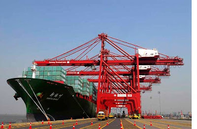
The coastline of India is dotted with 12 Major Ports and about 200 Non-major Ports. The Major Ports are under the purview of the central while the Non-major Ports come under the jurisdiction of the respective State Governments.

The 12 Major Ports (including the Port of Ennore which is a corporate port set up under the Indian Companies Act, 1956) are evenly spread out on the Eastern and Western coast. The ports of Kolkata, Paradip, Viskhapatnam, Chennai, New Mangalore, Mormugao, Mumbai, Jawaharlal Nehru at Jhavasheva and Kandla are on the Western Coast. The capacity of major ports have increased from 20 Million Tonnes per annum (MTPA) 1951 to 504.75 as on 31st March, 2007.

Friday, July 27, 2012

Indian Shipping

Shipping plays an important role in the transport sector of India's economy. Approximately, 90 per cent of the country's trade by volume (70 per cent in terms of value) is moved by sea. India has the largest merchant shipping fleet among the developing countries and ranks 20th amongest the countries with the largest cargo carrying fleet with 8.83 million GT as on 01.06.2008 and the average of the fleet being 18 years.


Indian maritime sector facilities not only transportation of national and international cargo but also provides a variety of other services such as cargo handling services, shipbuilding and ship repairing, freight forwarding, lighthouse facilities and training of marine personnel, etc.

Indian Roads

India has one of the largest road networks in the world, aggregating to about 33 lakh kilometers at present. Though the National Highways, which is the responsibility of Central Government, has length of roads, carries over 40 percent of the total traffic across the length and bredth of the country.


National Highways/Expressways 65,590 km
State Highways 1,28,000 km
Major and other Disctric Roads 4,70,000 km
Rural Roads 26,50,000 km


The National Highways have further been classifed depending upon the carriageway width of the Highway. Generally, a lane has a width of 3.75 m in case of single lane and 3.5 per lane in case of multilane National Highways. The break-up of National Highways in terms of width is as under:-

Single Lane 32 %
Double/Intermediate Lane 56 %
Four Lane/Six Lane/Eight Lane 12 %

Indian Railways

The Indian Railways has been a great integrating force during the last more than 150 years. It has bound the economic life of the country and helped in accelerating the development of industry and agriculture. From a very modest beginning in 1853, when the first train steamed off from Mumbai to Thane, a distance of 34 kilometers Indian Railways has grown into a vast network of 6,909 stations spread over a route length of 63,327 kilometers with a fleet of 8,153 locomotives, 45,350 passengers service vehicles, 5,905 other coaching vehicles and 2,07,719 wagons as on 31st March, 2007.


The growth of Indian Railways in the 150 years of its existence is thus phenomenal. It has played a vital role in the economic, industrial and social development of the country. The gauge-wise route and track lengths of the systems as on 31st March, 2007 are as under:-

Gauge Route in Km Running Track in Km Total Tack in Km
Borad Guage (1.676 mm) 49,820 71,015 93,386
Meter Guage (1.000 mm) 10,621 11,487 13,412
Narrow Guage (762 mm and 610 mm) 2,886 2,888 3,198


The network is divided into 16 zones. Divisions are basic operating units. The 16 zones are their respective headquarters are given below. 

Zonal Railways Headquarters
Central Mumbai CST
Eastern Kolkata
Northern New Delhi
Northern-Eastern Gorakhpur
North-East Frontier Maligaon (Guwahati)
Southern Chennai
South Central Secunderabad
South-Eastern Kolkata
Western Church Gate, Mumbai
East Central Railway Hajipur
East Coast Railway Bhubaneshwar
North Central Railway Allahabad
North Western Railway Jaipur
South-East Central Railway Bilaspur
South-Western Railway Hubli
West Central Railway Jabalpur

States and Capital of India


Geography Facts about India

Location
  • The Union of India is the seventh largest country in the world covering an area of 32,87,590 square kilometers and it is an important country of south Asia.
  • South Asia has a total area of about 4.488 million sq. km out of which India has the largest area (3.287 sq. km). It occupies 73.2 % of total area.
  • It is 4 times largest than Pakistan which is second largest in South Asia. India is 12 times largest that UK and 8 times largest than Japan.
  • The mainland stretches from latitude 8o4' north to 37o6' north and from longitude 68o7' east to 97o25' east of Greenwhich. The latitudinal and longitudinal extent of the country is almost same in degrees i.e. about 30 degrees.
  • The southernmost point in Indian Territory, (in Great Nicobar Islands) is the Indira Point (6o45’ ), while Kanyakumari, also known as Cape Comorin, is the southernmost point of Indian mainland. The country thus lies wholly in the northern and eastern hemispheres.
  • The 82o30' E longitude is taken as Standard Time Meridian of India, as it passes through the middle of India (from Naini, near Allahabad.) Hence Naini, Near Allahabad is the Standard Time of India.
  • The country is of a vast size and measures about 3,214 kilometers from north to south and about 2,933 kilometers from west to east.
  • Indian Standard Time:- GMT +05:30
  • Telephone Country Code:- +91
  • Coastline:- 7,516.6 km encompassing the mainland, Lakshadweep Islands, and the Andaman & Nicobar Islands. 
India Facts
Territorial Sea 12 nm (nautical miles)
Contiguous Zone 24 nm
Exclusive economic Zone 200 nm
Continental Shelf 200 nm or to the edge of the continental margin
Longest River Ganga
Largest Lake Lake Chilka
Highest Point Mt. K2 (8611 m)
Highest Point of Himalaya Kanchan Junga (8,598 m)
Lowest Point Kuttanad (-2.2 m)
Northernmost Point Siachen Glacier near Karakoram
Southernmost Point Indira Point, Great Nicobar, Andaman & Nicobar Islands
Southernmost Point of India (Mainland) Cape Comorin (Kanya Kumari)
Westernmost Point West of Ghuar Mota, Gujarat
Easternmost Point Kibithu, Arunachal Pradesh
Highest Altitude Kanchenjunga, Sikkim
Lowest Altitude Kuttanad (Kerala)

Constitution of India and Polity

The present constitution of India was framed by the Constitution Assembly of India setup under Cabinet Mission Plan of May 16, 1946.

Composition of Constituent Assembly:-
  • The Constituent Assembly consisted of 385 members, of which 292 were elected by he elected members of the Provincial Legislative Assemblies while 93 members were nominated by the Princely States. To these were to be added a representative each from the four Chief Commissioners Provinces of Delhi, Ajmer-Marwar, Coorg and British Baluchistan.
  • Each Province and each Indian State or group of States were allotted the total number of seas proportional to their respective population roughly in the ration of one to a million.
  • B N Rao was appointed the Constitutional Advisor of the Assembly.
  • The first meeting of the Constituent Assembly took place of Dec 9, 1946 with Dr. Sachidanand Sinha as its interim President. Dr. Rajendra Prasad was elected as its President n Dec 11, 1947.
  • The Assembly framing the Constitution.had 13 Committees.
  • The all-important Drafting Committee, which bore the responsibility of drafting the Constitutional document during the recess of the Constitutent Assembly, from July 1947 to September 1948, was formed on August 29, 1947. Its members were:
    1. Dr. B.R. Ambedkar
    2. N. Gopalaswami Ayyar
    3. K.M. Munshi
    4. Syyed Mohd. Saadulla
    5. N.Madhav Rao
    6. D.P.Khaitan (T Krishnamachari, after Kahitan’s Death in 1948)
  • It was finally passed and accepted on Nov 26, 1949. The session of the Assembly was held on Jan 24, 1950, which unanimously elected Dr, Rajendra Prasad as the President of India. In all the 284 members of the Assembly signed the official copies of the Indian Constitution which came into effect on Jan 26, 1950, known and celebrated as the Republic Day of India.

Thursday, July 26, 2012

Tarkarli

Tarkarli  is a village in Malvan Taluka, district Sindhudurg. It is Tourist Destination in Coastal Maharashtra, an attractive beach. From there, one can see the famous naval fort Sindhudurg built by Shivaji Maharaj. This village is famous for its Ramnavmi Utsav. Here in Mapurush Temple the celebration of Ramnavmi is arranged every year. To mark this occasion there are various dramas (Marathi Natak) are arranged.


This place has gained prominence because of its long and narrow stretch of beach with pristine waters. On a fairly clear day, one can see the bed unto a depth of 20 ft. It presents a panoramic view with tall 'Shuru' trees in the background. The wide river, the beautiful sailboats and the tiny wonderful islands hamlets situated on the riverbank, add to the picturesque beauty of Tarkarli. Sighting dolphins is not a rare event here. This place fishes throughout the year, the sea during summer and winter and back-waters during the monsoon since the sea water enters this area and also due to safety reasons.

Kashid Beach

Located in Maharashtra, this beach is located near Janjira at Murud. It is about fours hour drive from Mumbai, but the peace and quiet are worth it. Kashid is quite close to Alibagh and can be taken in as a day trip if you are holidaying there.